Sunday, July 19, 2015

Design Project


Foothill Blvd Redevelopment Project


Presented by

RAD Raadgevend
Kevin Carstens, Kaylinn Roseman, and Alex Sandoval


Proposed Area:

Foothill Blvd from Ferrini Rd (west) to east of Santa Rosa St (east)

Project Issues/Challenges:


Our Plan:


Cost:

Responses to a few Email Points:

Construction costs: We may have double counted the construction costs for some of the items.  For instance, the raised pedestrian platform is the cost per installation.  Installation means that it includes labor/construction costs.  Aligning broad with Chorro is almost all construction.  If we do a rough recalculation, we get:
$2,400,000

This comes from removing the alignment, and adjusting the costs of intersections.  The intersections included construction in most cases.  Recalculating to remove the double counts is important because firms compete through bids.  If an engineer miscalculates/double counts, he could potentially cost his firm the job.

People plazas:  When we mentioned people plazas, we pedestrian-oriented areas.  In a "people plaza" we would expect to see storefronts with housing above; everything the residents need is within walking distance.  The result would be similar to the new development in Rijswijk.  Ideally, these developments would be car free.


Final Reflection

I just arrived back at my home.  The Netherlands treated me well.  If I didn't have other commitments, I would have had no problem hanging out there for the rest of the summer.  Since my other blog posts explain infrastructure, this final reflection will be focusing on how/if Dutch design could be incorporated in the US.

After spending two weeks in the Netherlands, I realized that the biggest challenge in making our country more bike and pedestrian-friendly will be changing the mindset of the population.  The presenter summed up the problem with a US subset perfectly.  The said population consists of the "manly men."  He said that the reason why the Dutch are bike-friendly is because they see their bikes and cars as tools.  Thus, rusty bikes don't bother the Dutch.  The earlier mentioned "manly men" argue that we have cars, therefore we don't need bikes.  Many of these people exist in my area of SoCal.  They wouldn't ride a bike if their lives depended on it.  If we could convince these guys that a bike was their most important tool for short-range transportation, we could convince anyone and everyone in the US.  Without this mental change, implementing Dutch features would be like making lemonade with salt instead of sugar.  It would not taste good.

My final thought about bringing Dutch influence to the states is about population density.  The US' population density is significantly lower than the Netherlands.  In one of the presentations, we learned that the Netherlands' population density is about ten times greater than the US.  The other thing that we learned was the policy in the Netherlands.  They try to limit sprawl as much as possible.  Also, they limit big box stores as much as they can.  This keeps the towns small and dense.  Bike mobility in small dense towns is better than in large sprawling communities.  I think an improvement that we can make is to limit development.  Before sprawling, we should increase the density of existing cities.  By doing so, we can start to implement the Dutch design that works better in their dense cities.

Overall, I enjoyed my studies.  I feel that I have been equipped with a new arsenal to use later on in my career.  I hope to return to the Netherlands in the future.

Initial Impressions of the Netherlands

On July 2 2015, I arrived in the Netherlands.  My first exposure to the country was via Schipol station/airport.  I was surprised that the airport was also a train station.  It made me think wonder why LAX didn't have rail.  From my experience, it can take up to an hour to travel the last few miles to LAX due to congestion.  If you compound that with the general gridlock of the terminal traffic, it is not enjoyable to drive there.  Adding a train station to LAX would only make sense.

After taking a train, I arrived in Delft.  My first thought after getting in the station was that I was going to die.  It was about 90 degrees (F) with 90% humidity.  That being said, my first thought was actually pure amazement toward the bike garage.  Coming from California, the highest density of bikes I had previously seen was in a bike shop.  I estimate that I saw 500 bikes just by looking through one window of the garage.  At this moment, I figured out that the Netherlands was infinitely more bike-friendly than the US.

During my walk to TU, I learned about two things: pavers and permeability.  Pavers, in my opinion, are more attractive in pedestrian areas than concrete or asphalt.  That being said, it was very difficult to move my luggage across them.  On older pavers, I found myself frequently losing control of my rolling duffle bag.  The broken corners and sunken bricks made the bag twist and turn.  In addition, the wheels rolling over the pavers were extremely noisy.  The other thing is noticed was permeability.  Delft often used bollards to prevent through movement of cars.  As a result, we pedestrians did not have to constantly worry about cars.  In addition, the selective permeability optimized and prioritized routes for bikes and peds.  Had there not been a canal in our route, our journey would have been pretty straight.

Overall, the city was charming and I could not wait to experience more of it.

Wednesday, July 15, 2015

Photo Assignment

In this post, I will display (in a semi-random order) photos that I have taken in the Netherlands.  Each photo will be accompanied by a caption that will be more or less technical depending on the content.


This windmill is in Delft by the new train station.  I posted this because it answered a question I had back in winter quarter's structural analysis class.  We were estimating the weight of a building when I curiously asked, "When will we ever have to lift a building?"  Six months later, I stumbled across the answer.  Engineers had to lift this windmill in order to put an underground rail tunnel under it.  


This is a roundabout.  These are a valuable tool for maintaining flow while calming traffic for pedestrians and bikes.  It is hard to see, but this photo shows that bikes, pedestrians, cars, and public transit can coexist in a roundabout.


The main focus of this picture is the road marking.  These are called "shark teeth."  When the teeth are pointed at you, you have to yield to traffic.  The Netherlands uses these to replace stop signs because stopping is less efficient and isn't necessary when the intersection is empty. 


The Netherlands often uses bollards as semi-permeable barriers to prohibit through movement of cars while still allowing passage of bikes and peds.  There is also an automatic barrier in this picture that raises during certain hours to block car traffic.


This is a  wait countdown at a traffic signal.  These would be useful in the US!


This is how the Nike European HQ informed people that this space was motorcycle parking.


This is a 3-level bike parking facility in the Utrecht train station.  It is considered a "small" facility with the capacity for 4,200 bikes.  It is mostly lit by natural light coming from windows in the staircase above the garage. 
  

This sign shows the Rij (row) of the bike facility along with the Vrij (free) spaces.  The free spaces are refreshed every 15 seconds according to the occupancy of sensors in the bike racks.


This person added a flower-wrapped basket to her bike to easily identify it.  People often add objects to find their bikes in the endless abyss of bike parking.


The main focus of this photo is the concrete rail going down the stairs.  There is a notch on each side of the rail to assist people in rolling their bikes down the stairs.  Notice that the staircase is wide enough to have four people moving their bikes down the stairs with room to spare.


These are the OV-fiets.  They are the bikes used in the main bike sharing program in the Netherlands.  People will often have two bikes at two different stations if they regularly ride in different towns.  Since parking is limited, the Netherlands has suggested that the public use one bike.  Since bringing your bike on the train costs 6 euros, the OV-fiets program is a steal at 3.15 per day.


These are the stairs with the windows that I mentioned a few photos ago.


Here is a random UFO that "crashed" in Utrecht.  It was meant to be a temporary art display, but people loved it so much that the city decided to keep it.


This is a traffic calming feature called a bayonet.  It reduces the width of the road, causing traffic to slow.


This is De Oversteek.  It is a ped-bike bridge that opened last summer.  It rotates counterclockwise to allow boats to pass.


Here is a pair of tube sensors at the end of De Oversteek.  Normally, only one tube is necessary for counts.  After some discussion with the professors, I concluded that the second tube is used to tell direction and possibly velocity.


Here is an area where the same street has opposing one-way sections that meet.  The raised platforms and bollards force the cars to turn left or right.  The use of bollards allow for bike and ped passage through the entire intersection.


Here is a protected intersection on a road that has separated sections for each mode of transportation.  This is multi-modal interaction done right!  I wish that planners had though of a less cluttered way to signalize the intersection.  


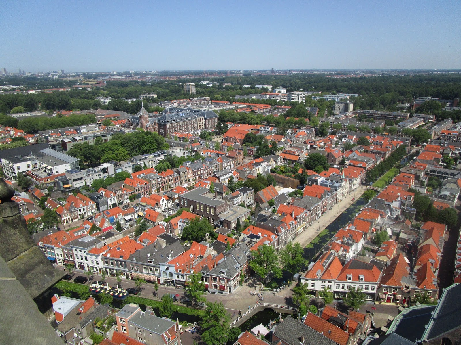
This is a picture of Delft from the top of the New Church tower.  If you look closely, you can see IKEA in the background.  The reason why I like this picture so much is because it shows you the bike network in a way that you can only see from the sky: as lines of trees.  As I looked around, I followed the various routes that I took to my usual locations.


This picture shows a broken segment of green due to construction.  When it is finished, it will get trees and become part of the green network.


How could I NOT include a bird's-eye view of a canal?


Here is a bridge that has just opened to allow boat passage.  This bridge is interesting because it is a cantilever.  Most of the boat bridges I have seen are two-part or rotating.


Here is the organ in the Old Church.  It is the most beautiful instrument I have ever seen.  The sound that it produced was majestic.  European organ players come from all over to play it.  The Old Church's organ is considered the premier organ in Europe.  If it didn't have over 2,200 pipes, I would consider taking it as a souvenir.


Here is a picture of the Old Church tower.  As you can see, it is not exactly straight.  This reminds me of something else that leans in Europe... Watch out Italy!


As a reward for making it through this post, here's a piece of pie.  You earned it! :)


Tuesday, July 14, 2015

Delft Facility Tour #2

On 9 July 2015, we toured Delft for a second time to examine more facilities.  Although rain made the tour less enjoyable, it allowed us to see the drainage of the facilities in action.

Underpasses & Bridges:

Since the water table is high in the Netherlands, subsurface structures are difficult and thus, expensive to build.  The main purpose of an underpass is to safely connect two bicycle facilities while bypassing longer routes.  Bridges have the same function as underpasses.  From my experience in Delft (so far), bridges are mainly used for connecting bicycle facilities on opposite sides of canals.  Underpasses are used for going under high volume streets and train tracks.  Click this link for more on underpasses and bridges.

Bike Lanes:

Bike lanes are space on the roadway designated for bicyclists.  It differs from a cycle track in that it is not protected from car traffic.  The main difference I saw, when compared to US bike lanes, was the width.  In California, the minimum width a bike lane can be is 5'.  While this is plenty of room for a cyclist, it leaves out one important detail: the gutter.  Most California streets have a gutter averaging 1.5' wide.  Often, the gutter graded is too steep and/or there is debris in the gutter.  This makes the gutter impractical for a bike lane.  Thus, a 5' bike lane is actually a 3.5' bike lane.  Not only is the gutter making the bike lane narrower, but the unusable space forces the cyclist to ride closer to traffic.  Gutters in the Netherlands are only one to two bricks wide.  For more on bike lanes, click this link.

Advisory Bike Lanes:

Advisory bike lanes are roads where there are designated lanes for bikes, but the cars have to maneuver.  In my opinion, advisory bike lanes are like sharrows for cars.  Think of it, sharrows make bikes at like cars.  Advisory bike lanes make cars act like a bike would in the US.  The sharrow vs advisory bike lane just changes which mode is negotiating with the other fixed mode.  For more on advisory bike lanes, click this link.

Monday, July 13, 2015

7/6 Delft Facility Tour #1

On 6 July 2015, the Portland State and Northeastern University students teamed up to explore bicycle-friendly facilities around Delft.  This blog post will highlight the main attractions of Facility Tour #1.  I will provide group analyses via the Northeastern blog (links).

Stop #1: Woonerf


The first stop of our journey was to see a woonerf.  This name doesn't sound too technical, but it is fun to say.  In fact, the playfulness of the word kind of captures the impact it has on neighborhoods. Woonerfs are implemented in residential streets to promote pedestrians.  The main features include slowing auto traffic and relocating parking (out of street).  Getting back to the playfulness of the word, a woonerf results in a neighborhood where kids can play safely and freely.  For more on woonerfs, see the Northeastern blog.

Stop #2: Roundabout w/ Bike Priority


The second stop on our tour was a roundabout.  Since we are in the Netherlands, the Dutch decided to add a bike lane to the roundabout.  The geometry, pavement markings, and signage give cyclists priority throughout the entire roundabout.  Theoretically, a cyclist could circle for hours without having to yield or stop.  A key safety factor is the lighting; it is placed so that each point of conflict is illuminated at night for each mode.  For more on the roundabout, visit the Northeastern blog.

Stop #3: Buitenwatersloot


Buitenwatersloot is a bicycle boulevard along the canal near Oude Delft.  It has a semipermeable barrier to allow for through movement of bikes, but inhibit the through movement of cars.  The barrier along this section had a control to lower for the local buses.  By eliminating the through movement of cars, the bike boulevard has limited the auto users of the road to delivery drivers and local residents,  This allows for a bike-friendly environment.  For more on the Buitenwatersloot, see the Northeastern blog

Stop #4: Two-Lane Cycle Track


A two-lane cycle track provides a separated and protected path for bicycles.  The thick white lines contrasting with the red pavement provides a clear message to drivers that they are approaching a two-lane cycle track.  In addition, the cycle track remains level through intersections.  Not only do cars have to yield to the cycle track, but they are forced to yield through elevated platforms.  For more on the two-lane cycle track, visit the Northeastern blog.  In the Northeastern blog, I suggested a potential site for a two-way cycle track in my hometown (Yucaipa, CA). *Note: The Cycle Track blog for my group is having technical difficulties, I will update this posting when the problem is resolved.*

Stop #5: Protected Intersection


Yes, EVEN the Netherlands has large signalized intersections.  When I see an intersection in the US, the bike line is either poorly positioned or it is non-existent.  This intersection is called a protected intersection because it protects both bikes and pedestrians while moving auto traffic.  The cycle paths are separated making it almost impossible for a right hook or any kind of car-bike incident to occur.  Pedestrians have refuges in the crossings so that they don't have to worry about not crossing the road.  If the light changes before they finish crossing, they simply wait at a refuge for the next cycle.  This allows for optimized signal cycles and pedestrian safety.  Cars are also protected.  When a car gets stuck in an intersection in the US, the driver is often put in a difficult situation: rejoin traffic or continue through.  There are refuge areas for drivers who cannot complete their left and right turns.  Just like a pedestrian, they can comfortably wait for the next cycle.  For more on protected intersections, see the Northeastern blog, **See Stop #4 Note**


Friday, June 26, 2015

Cycling Amsterdamsestraatweg, Utrecht, Netherlands

Link for video: https://www.youtube.com/watch?v=FOkbz4tm324&feature=youtu.be

The first thing that caught my attention in this video was the history of the road shared in the first minute.  I am curious to know how many of the people riding knew that they were on Napoleon's Imperial Route No. 2.  That road reminds me of Mt.Vernon Ave in San Bernardino, CA.  Mt.Vernon is actually Route 66.  I remember singing about Route 66 when I was younger, but I had no idea that I was so close to the historic road.  Going back to the video, the images shown captured innovation.  When I looked at the 1890's picture, I noticed dirt roads and no bicycles.  Jumping to the 1930's, I noticed the electrical lines hanging, the cobblestone road, and abundant bicycles.  This is interesting because "safety bicycles" were invented around 1890 to replace the ridiculous big wheel.  As we can see, the safer bicycles caught on with the help of a paved road.  As we approach the 1970's, the road was paved over with asphalt, and the number of cars on the road increased.  It seemed like the cars and bikes shared the road.  In the 1970's, the trees along the road were knocked down, and there was a distinct bike lane.  As time went on, the bikes got separated from the motorists, creating beautiful islands with trees and bike parking that was far more plentiful than car parking.

The other element that was neat was the synergy and calmness of the current road.  In the 6 minute video, the cameraman stopped once.  He did a good job of pointing out neat features like the bike left turn lanes.  His use of short annotations helped toss in many facts and features without detracting from the experience.  Based off this video, I believe that a similar road layout could work in downtown SLO.  It would need some modifications since the cross-streets tend to get congested during the daytime.  An induction loop detector signal light would probably be most appropriate for the queuing, however, the bike lane might need an IR sensor to double-check bike presence.

Overall, I liked the video.  The music made the ride that much more enjoyable.  After seeing this, I can't wait to cycle in the Netherlands!

~Alex